


VG4D Production Manager™
Proven Production Experience
Virtual Geomatics' VG4D Production ManagerTM suite is built on a decade of high-volume, high-quality, award-winning production experience. The software's key characteristics: accuracy, dependability, ease-of-use and efficiency, make it a sure winner in a marketplace that demands a single-sourced wholly, integrated production management solution.Streamlined Workflow Integration
VG4D Production Manager, the flagship software offering from Virtual Geomatics is is the new standard for the industry.. The company, guided by seasoned software executives and mapping professionals, is fervently committed to the innovation of software products that deliver quantum leaps over today's market leaders with new integrated capabilities for improving the production and exploitation of today's rich, 3D datasets and the new complex multi-dimensional datasets expected as the complexitiy of point cloud data accelerates.Invigorating Established Markets
Whether from airborne, terrestrial, or other sources, VG4D Production Manager is designed to help users from all types of mapping firms: Federal, State, and local governments; civil, survey, and environmental engineers; forestry and natural resources professionals; educational and research institutions, and any other geospatial professionals identify, classify, analyze, manipulate, utilize and distribute multidimensional data products.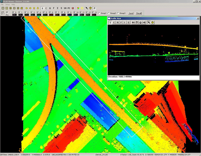
Raising Expectations
VG4D Production Manager is an exciting step forward for the geospatial software
industry. It is raising the bar in customer expectations for both
functional capabilities and creative, insightful solutions with
aggressive, competitive strategic solution pricing from market
leading solution developers.
Refine Your Company's Production Reality
Take the next step forward with us and enjoy the advantages delivered
to your projects by Virtual Geomatics and their VG4D Production
Manager suite.
Product Features
>Stand-alone; no 3rd party software required>Multi-user functionality
>LAS 1.1 and 1.2 compliant
>Functionality to run large projects on multiple systems across a network
>Easy to use, efficient one button ground filter
>Higher throughput and quality thatn competitive products
>Integrates seamlessly with VG4D Data Manager to lower cost of operations
Workflow Management
>Process-oriented workflow manager>Import either flightline or existing tiled data
>Database tracking of project and data flow status, including a spatial view of project status
>Creation and monitoring of data tiles
>Record your own filtering macros
>Batch filter by tile or polygon selection using pre-recorded macros for different terrain types
>Create filtering scenarios to follow specificed terrain characteristics
>Versatile and easy-to-use, one step ground filter for all terrain types
>Manual editing tools for final cleanup
>Export and track products
GeoTIFF
Shaded relief
LAS
GIS product formats
DXF
BIN
>Product quality report and metadata generation
>Production metrics
VG4D Production Manager Filtering
>Advanced pre-eminent filtering and editing tools>Easy-to-use, efficient one-button Ground Filter
>Set of fully customizable filters:
High/Low point filter
Edge match filter
Classify by LSF (LiDAR Spectral Fusion)
Multiple return analysis filter
Vegetation filter
Advanced vegetation filter
Ground filter
Ground modeling filter
Building clean-up filter
Classify nearby points
Noise filter
Reclassify
LSF color adjustment
Model key-point filter
>Custom parameter options for each filter
Tool Box
>LSF -LiDAR Spectral Fusion - LiDAR points attributed with spectral band information>Import
ASCII
LAS
GIS formats
>Export
Elevation
Intensity
Contours
Shaded Relief
LSF
GeoTIFF image files
LAS 1.2
ASCII
GIS formats
DXF
BIN
>Creat and export 3D contours
>Re-projection options
>LAS and ASCII gridding
>Breakline drape / conflation
>LAS transformation - Adjust XYZ values, shift, scale, rotate
>Stand alone, quality report generation
>Point density calculation
>Advanced import /export product capability
3D Visualization
>Powerful and easy-to-use 3D data viewer>Memory optimization allows visualization of very large datasets, at one time
>Profile view editing
>Integrated manual editing and manual reclassification tools
Linked 2D/3D view - rapidly identify and visualize tiles for display, QC or editing
>Visualization modes
Shaded relief
Elevation
Return intensity shading
Color by classification
Color by flight line
Pseudo contours
LSF - LiDAR Spectral Fusion
>One-button classification visualization
>Intuitive 3D rotation, panning, zoom, vertical exaggeration, azimuth, on-the-fly 3D TIN rendering, and on-the-fly 3D contour visualization
>GPS time, coordinate, return, intensity and filename readout by cursor location
Contouring
>Full featured toolset to create 3D breaklines by draping 2D vectors>Create cartographic quality contours - with full control over "smoothing" and minimum isolation size
Project Management
>Metrics reporting>Track time by machine
>Track time by task
>Track time by staff member
>Real-time database update during production/edit/quality control
Pricing
VG4D Production Manager is available now for purchase. Contact VGI for Network based and other portable licenses at sales@virtualgeomatics.com. To purchase, contact our sales department at 877.VG4D WIN ext 111 (877.844.3946), or email sales@virtualgeomatics.com.Download Data Sheets VG4D Production Manager Data Sheet
