
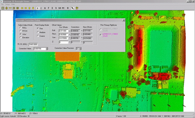
LiDAR Boresite Module
Growing Complexity
Over the past decade, airborne LIDAR data has increasingly become the primary choice for acquiring dense and precise digital elevation models of larger areas for a wide range of applications. In order to achieve maximum accuracy, it is imperative to calibrate a LIDAR system by determining corrective offset values for Roll, Pitch and Yaw. Due to the complexity of these 3-D misalignments, it can be a very intricate and stringent effort to calculate these corrections at the same time.
Simplified Real-time Visualization
While current common approaches to modeling a boresite solution employ tedious profile-based corrections, block adjustment corrections or intensity imagery and correlative methods, purely analytical techniques of solving a boresite are made much easier when combined with real-time subjective visualization.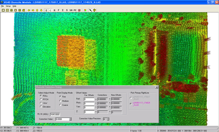
The VG4D Boresite Module approach does not pose any special conditions regarding flight altitudes, course directions or terrain details, but only requires two LIDAR strips flown in opposite directions along the same course at the same Above Ground Level (AGL) height.
Sophisticated Versatility
The new, versatile, user-friendly method adopted in the Boresite Module suggests a more efficient approach than others commonly available. By manipulating the data in real-time, this sophisticated 3D technique finds the needed parameters to correct boresite misalignments without excessive requirements and processing steps. It requires no special attention to or conversion of data, such as developing correlation grids or images. Furthermore, it is not necessary to pick particular areas which contain specific features for processing purposes, nor for the data to be flown at multiple flight heights.Efficient Accuracy
The VG4D Boresite Module has consistently yielded precise offset values in less than four iterations; our successes show that it is not uncommon to solve a boresiting in less than thirty minutes.
Product Features
>Stand-alone; no 3rd party software required
>Handle multiple LAS files simultaneously
>3D display and manipulation of data points
>Visualization modes
Shaded relief
Elevation
Return intensity shading
Color by classification
Color by flight line
Pseudo contours
LiDAR Spectral Fusion (LSF)
>Intuitive 3D rotation
>Data pre-classification of above-ground feature points
>Real-time visual modeling of horizontal and vertical discrepancies
>Display of the modified value results in real-time
>LAS 1.1 Compliant
Download Data Sheets LiDAR Boresite Module Data Sheet
